
Fort Branch – Guardian Of The Upper Roanoke River
By Larry Babits · Originally published February 2017 · pp. 26–27
Fort Branch is a Confederate earthwork fortification in Hamilton, N.C., that once guarded the upper Roanoke River, its naval yards and the railroad bridge connecting the Army of Northern Virginia with Wilmington. The fort site is on privately owned land, the property of the Winslow Family. It is on the National Register of Historic Places and thus enjoys some protective assistance from the Winslows, Fort Branch Battlefield Association, the recreated First North Carolina Regiment and state and federal governments. This brief article is about the fort, its history and future. The fort’s future is now endangered because two large parapet segments (over 250 feet) collapsed into the Roanoke River during September and October 2016. It appears that, after 150 years, the fort is finally succumbing to the forces of nature.
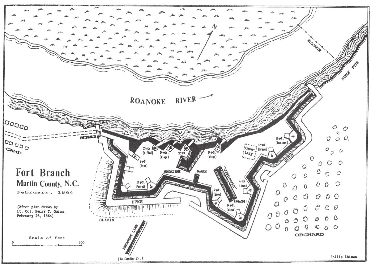
History of Fort Branch Fort Branch was built to protect the upper Roanoke River valley. This was a crucial assignment since the Confederates were building an ironclad, the CSS Albemarle, at Edwards Ferry just upstream. There was also a navy yard at Halifax farther upriver. Finally, and ever more important as the Union blockade progressed, the key railroad system connection between the Army of Northern Virginia and the South crossed the river at Weldon, a short distance above Halifax. Cutting this crucial link would create major obstacles in supplying Lee’s army. Fort Branch went through two main construction periods. The first was during the late winter and spring of 1862. After Federals seized the North Carolina sounds, they could easily transport raiding parties anywhere reachable by water. While troops were sent to guard the bridge at Weldon, men were also sent to Hamilton where Rainbow Banks offered high ground. During February 1862, Captain Richard Kidder Meade, a Confederate engineer, requisitioned slaves and provisions and began erecting two batteries at Rainbow Banks, a steep bluff where the Roanoke made a turn to the east. Meade was assisted by the 34th North Carolina Infantry, Nichol’s Virginia Light Artillery and some cavalry. Due to Union advances against Richmond, the defenders were ordered away before the works were finished. In September 1862, the battery was described as “well located” and “arranged for five pieces.” The parapet was “not more than 14 feet thick” and thus potentially unable to withstand the Federal Navy’s heavy guns. The embrasures were not sloped to depress the cannon enough to bring fire downstream. The fort’s magazine must have stood fairly high because it was described as the “most conspicuous point…as viewed from the river” but it did not have sufficient covering to protect it. In July 1862, three Union vessels left Plymouth, N.C., and headed up the Roanoke. The Commodore Perry, a converted New York ferryboat, was perhaps the best adapted because it could steam in either direction without turning around, a necessity on the narrow rivers. The Shawsheen and Ceres were converted sidewheel steamers. Moving upstream, the ships were fired on. Returning fire, the flotilla moved upstream, passing the evacuated works at Rainbow Banks, before reaching Hamilton. A raiding party landed but was recalled as the ships returned to Plymouth. The brief raid caused a rethinking of the river defenses. By September 1862, Confederate engineers were again at work, assessing the river and locating points for obstructions and fort. They were not simply looking at the Roanoke but the Tar and Neuse as well because all three rivers had ironclad construction sites and the rivers provided access to railroad bridges. In mid-October, 500 slaves with provisions were requisitioned from local planters to start work on November 3. This work was halted because a Federal force (Foster’s Raid) came into the region from Washington, N.C. Naval forces operating as part of Foster’s Raid attempted to destroy the fort but failed although the magazine was blown up, some materials burned and embrasures damaged. The damage was apparently quickly repaired as the fort’s guns were finally mounted by Feb. 9. At this time, the fort resembled a bridgehead with local alterations (Figure 1). It was basically a “crown work” with a central bastion flanked by two demi (half) bastions on the land face. The river face was intended to have four cannon firing through embrasures angled to sight down river toward the bend and a nest of torpedoes. The outer 2 Nov. 2016 photo looking upstream, showing where parapet fell into river. trace would remain unchanged despite interior alterations that added traverses and structures within the year. A May 1863 inspection noted that the fort, “if properly garrisoned and provisioned” could repel “any attack by land or water” except a siege. The inspector reported the ammunition supply was “good, and provisions for 1,000 men for thirty days are being placed.” These figures suggest an upper cap rather than the regular garrison. From other documents, it is known that the garrison was largely composed of the 17th North Carolina Infantry. In actuality, that meant the 17th had its headquarters and two companies at the fort whilst other companies operated above and below the fort in conjunction with a battery of field artillery and cavalry. Companies G and H of the 10th N.C. (First Artillery) were stationed at Fort Branch after July 1863 When the 17th N.C. Inf. was ordered to Wilmington in October, its place was taken by the 24th N. C. Inf. until they went to protect the Weldon railroad crossing in Dec. When Plymouth was retaken by the Confederates in April 1864, Fort Branch was no longer the key defensive position on the river. It very quickly resumed that role when Federal forces retook the town in October. The fort was then garrisoned by N.C. Junior Reserves who had been marching to defend Plymouth. Together with a section of Lee’s Alabama Battery, they held the fort and provided outposts downstream to cover the torpedo nests. Since Fort Branch was important again, the garrison was upgraded by returning the heavy artillerymen and a company of light artillery. The garrison was often called away to repel raids and outpost the lower river. In December 1864, the fort was probed but not attacked even though its garrison was under strength. This failure was, in large measure, due to sinking two Union vessels downstream by torpedoes. Once the ships were sunk, the raid was stopped by sharpshooters and artillery firing from the bank below the fort. By April 1865, the fort was isolated as Confederate forces were pulled away to oppose Sherman’s armies marching into N.C. The end came April 10, 1865 when the garrison destroyed the fort and military stores. The guns were thrown into the river and buildings burnt. The Union Navy recovered at least three, and possibly four, cannon from shallow water in May 1865. The fort had done its job fairly well once completed. Naval construction upstream was not interrupted and it was only when the Confederacy was in its death throes that the fort was evacuated. Today Fort Branch represents one of the finest surviving examples of Confederate river defenses. The site’s value is enhanced by displaying eight cannon that helped block the river. A February 1864 report included a map showing the fort’s armament. At this time, there were three iron 6-pounders, two 12-pounders, three 24-pounder siege and garrison guns, a 20-pounder Parrot and a banded and rifled 32-pounder. Two additional land face emplacements were not occupied and, from modern inspection another gun position may have been underway on the river face. During 1972 and 1977, another seven cannon, plus the breech of a burst 32-pounder, were recovered. Given the three or four guns recovered by the Union Navy in 1865 and some the withdrawing garrison may have removed, the fort may have had as many as 15 cannon. Guns recovered during the 70’s included types not shown on fort plans. These weapons will be described in a forthcoming Artilleryman Magazine piece. Interest in the fort resumed during the Civil War Centennial and plans were made for conserving the site. These eventually resulted in placing Fort Branch on the National Register of Historic Places and manning the fort with a periodic garrison of reenactors. The fort is administered by the Fort Branch Battlefield Commission which stages events and opens the fort on summer Saturdays and Sundays. Aside from Confederate damage inflicted in 1865, the fort remained relatively untouched by human agencies until the 1930’s when John Hines, a local game warden with information from relatives who served in the war, excavated in the fort. Hines located a well and uncovered a large quantity of ammunition and artifacts including a small brass cannon. Although he kept some artifacts, others were placed on display at the office of the Enterprise Publishing Company, the local newspaper’s office. These artifacts have long since been scattered.
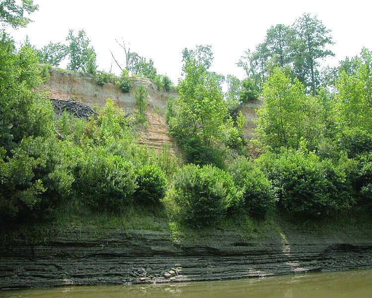
Fig. 4 Remnant of interior parapet footing.
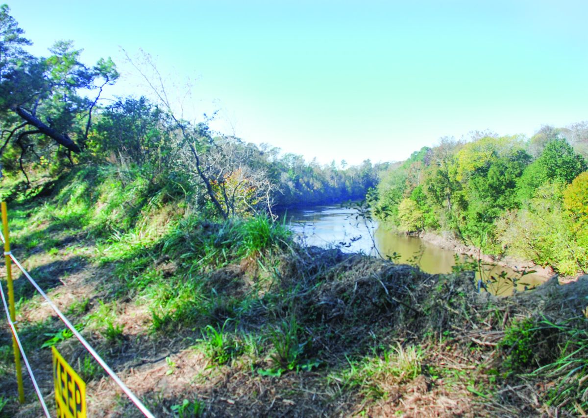
In August 1971, a group of U.S. Marines from Camp Lejeune equipped with ropes, underwater lights, shovels and a metal detector uncovered numerous shells and other artifacts. Photos of their exploits accompanied a feature article in the camp newspaper. Again, these artifacts and supporting information have been lost to time. The next year, spurred by the Marines’ recoveries, a group of relic hunters from Alabama, Wilmington and Rocky Mount, mounted an extensive effort in the river. In July 1972 they were able to retrieve “several hundred shot and shell ranging in size from 6 to more than 100 pounds.” They also found and recovered three cannon. When the Winslows learned that cannon were being recovered, they asked for help. Superior Court Judge Elbert S. Peel, determined that North Carolina’s Antiquities Law covered the situation and Sheriff Raymond Rawls served papers on the relic hunters. The resulting court case took two years to determine that the guns belonged to North Carolina and halted their removal. During the court case, the guns and carriages were conserved by N.C. conservator Leslie Bright and a brief article appeared in the Military Collector and Historian. In1973, and possibly 1974, East Carolina University conducted a small excavation into the “commissary” and two gun platforms. No documents of this work currently survive but are being searched for. In 1977 a major recovery effort under the auspices of North Carolina’s Underwater Archaeology Branch recovered four more cannon and conducted other survey work inside the fort. The cannon and their carriages are now on permanent loan to the Fort Branch Battlefield Commission and displayed at the site. A description of the fort in 1977 is provided in Gordon Watts’s 1979 report of the cannon recovery: “With the exception of the river face, particularly along the eastern [downstream] half, and minimal damage due to foot traffic, the earthworks at Fort Branch exist today in an excellent state of preservation. … the slope of the bank drops an average of 7 feet for every 6 feet out. Located on the outside edge of a major curve in the Roanoke River, the bank at Fort Branch is continuously subjected to lateral erosion by the river current. Several yards of the eastern half of the river face of the fort have sloughed off into the river as a result.” Things have changed dramatically since 1979. The entire line of rifle pits downstream has disappeared into the Roanoke. The river has cut into the blue gray clay underlying the bluff and this causes slumping from below (Figure 3). Storms that soaked the ground and weakened the grip of trees on the parapet caused damage from above. Most trees have since been removed; they were not there during the fort’s occupation. While cutting back on the trees helped ease the damage, several storms caused additional wall collapses. The most recent occurred about three weeks before Hurricane Matthew when some 60 yards of river face collapsed. Hurricane Matthew then took an addition 40 yards of the fort’s river parapet (Figure 2, 4). It is now clear that what the Yankees and the Confederate garrison could not do, Mother Nature is. The fort is in grave danger of losing the entire river face. Only two gun emplacements remain intact. Much of the eastern parapet is already gone. To remedy the situation and knowing full well that the river has a mind of its own, plans are underway to conduct archaeology at the intact emplacements to recover construction information before it is lost. The arrangement of the platforms for both pintle mounted permanent guns and siege and garrison pieces can then be compared to the land face cannon positions. It is hoped that work will take place this spring because the worst case scenario is that the river face will be more heavily impacted by storms than in the past. Copies of the fort’s history can be obtained from the Fort Branch Battlefield Commission, P.O. Box 355, Hamilton, NC 27840. Sources: • Fort Branch and the defense of the Roanoke Valley 1862-1865 by Phillip Shiman, T h i r d edition, 1990, Fort Branch Battlefield Commission • Fort Branch Survey & Recovery Project by Gordon P. Watts, Jr., et al Underwater Archaeology Branch, NC Division of Archives and History 1979