
Robert Sneden’s Map of Atlanta’s Confederate Defenses
By Stephen Davis · Originally published November 2016 · pp. 16–18
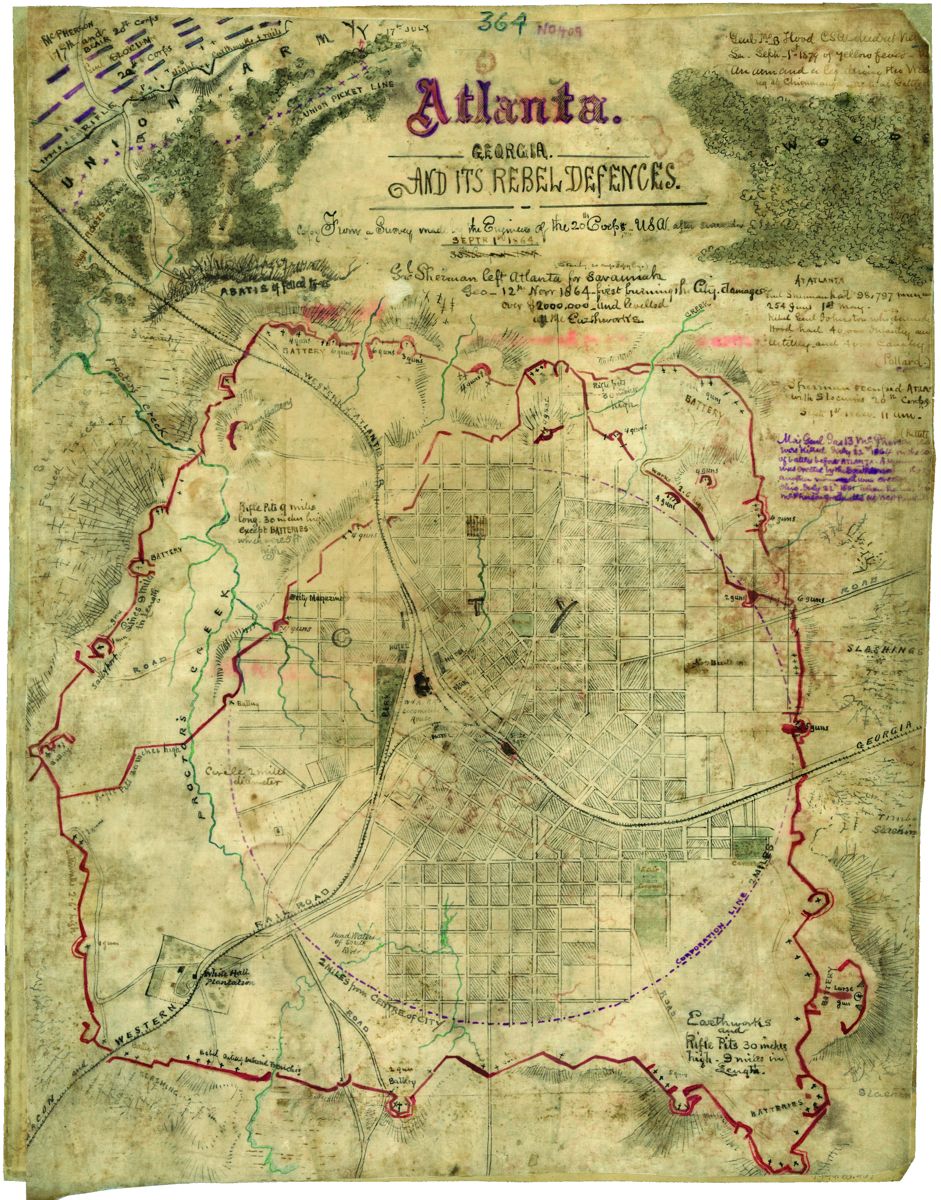
Students of the Atlanta Campaign have long bemoaned the scarcity of reliable maps covering the operations of Generals Sherman, Johnston and Hood. One has popped up in just the past few years, and it deserves a really good look. But first, background. When the Federal army got to Atlanta in mid-July 1864, Southern forces withdrew into the perimeter of earthworks surrounding the city, which had been under construction for months. Atlantans themselves had called for fortifications against Yankee cavalry raiders as early as May of 1863, after Col. Abel Streight led a Union mounted column into Georgia and got as far as Rome, sixty miles away (where Bedford Forrest tricked him into surrendering). Capt. Lemuel P. Grant of the C.S. Engineer Bureau (himself an Atlantan), took charge of laying out a line of rifle pits dotted by artillery forts, which eventually ringed the entire city (10-½ miles with twenty forts, alphabetized as A-U). Grant’s map of his line, dated April 12, 1864, is the only formal Confederate cartography we have of Atlanta’s defenses.1 The defenses, however, were still incomplete when William T. Sherman’s army group approached Atlanta. Gen. Joseph E. Johnston ordered the impressment of slaves to speed up the work. Even Northern spies learned of the activity. “General Johnston had ordered out every negro to work on the fortifications,” reported J. Milton Glass in a statement that made its way to Union headquarters.2 Word of the Rebels’ work trickled down even to the men on the front lines. “According to a reporte of a negro that was captord,” recorded
Cpl. Leander S. Davis (Battery M, 1st New York Light Artillery) on July 7, 1864: …there had bin four thousand negroes working for six weeks making stockades. This is done by digging a deep ditch and placing logs in it in an uprite position with the top of them sharpened and put closte together and dirt piled in the ditch and holes between the logs to fire out through…. Corporal Davis hoped that Sherman would find a way to flank the Rebels out of their works; “it is easier than to fite them out.”3 On July 18, after the Confederate government had relieved Johnston for his dilatory tactics, Gen. John B. Hood took command of the Army of Tennessee defending Atlanta. Within a day or two he had his troops digging new salients northwest and northeast of the city under supervision of the army’s chief of engineers, Col. Stephen Presstman. A prominent feature of the northwest bulge was a big artillery position near the Ephraim Ponder house (on today’s Georgia Tech campus), which Hood’s soldiers soon took to naming for their commander. “We left Fort Hood today and moved to the left to join our division,” recorded Sgt. Edmund Eggleston of Cowan’s Mississippi Battery in his diary on August 28.4 (I have not yet come across any evidence that an Atlanta fort was named for Joe Johnston.) Even in the last days of the campaign, before Sherman cut the Rebels’ last supply railroad and forced them to evacuate Atlanta, Hood ordered his defenses strengthened. Lt. Col. Bushrod W. Frobel, assistant chief engineer in the army, recorded in his diary that on August 20 he was siting a new artillery fort on land still occupied by civilians. When Frobel ordered the demolition of a man’s house, the owner protested; but eventually, he and his wife started moving out their furniture. The colonel observed that the proprietor told him he “could now proceed to tear down his nice little cottage and that he hoped the fort we were building would enable us to whip the Yankees.” Work continued in the next days, according to Frobel: “August 31st.—Large details, together with six hundred and fifty negroes, have been set to work on the inner lines, completing the redoubts and strengthening the position by connecting these with a heavy stockade of green timber.”5 The Yankees picked up on all of this work. A Union signal officer, Lt. Samuel Edge, customarily perched himself on platforms built in treetops and issued reports on what he had seen. On August 22 he wrote Maj. Gen. John A. Logan, XV Corps commander, “the enemy are busy strengthening their works and building new ones in front of the Twentieth Corps” (the XX held Sherman’s lines north of Atlanta). He also mentioned “the new casemate battery and six-gun fort south of the big gun and in front of the left of the Sixteenth Corps” – meaning on the western face of the Rebel perimeter. The “big gun” was a 9-inch, 64-pounder Dahlgren naval shellgun which had been brought from a Confederate gunboat moored well south in Florida. In late July it was evidently positioned at Fort Hood; Union Brig. Gen. John W. Geary reported: “the enemy throwing occasional 64-pound shells” from “a fort near the railroad and close to Mrs. Ponder’s house.”6 Confederate construction of new artillery positions in late August raises the question: how many forts did they finally build in the perimeter of earthworks surrounding Atlanta? The Southerners made no maps of the city’s defenses after mid-April 1864. After Sherman captured the city, his chief engineer, Capt. Orlando M. Poe, drew a map of the Rebel works. It shows the northwest and northeast salients of rifle pits dug by Southerners in July 1864, but is rather indistinct in identifying actual artillery forts placed along the entire Grant-Presstman perimeter (as I believe the city fortifications should be called). For instance, Poe gave alphabetic designations (A-G) to seven Rebel forts south of Fort Hood, but he apparently did not count the rest.7 Down here in Atlanta, we’re still trying to identify the Confederate forts surrounding our wartime city. Two years ago, Lawrence Krumenaker studied the Grant and Poe maps, superimposed them on a modern one and created a driving tour of the defensive perimeter. Along it, he counted thirty-six artillery positions, but his calculation is subject to question. He sites three forts in the northwest salient between Batteries X (Fort Hood) and K (sometimes called the “Peachtree fort,” now Fox Theatre).8 But back in the 1930s, when it was still possible to see earthworks in Atlanta, the redoubtable Wilbur Kurtz and Franklin Garrett counted four such earthworks, gave them names from nearby city streets, and indicated their sites on a big map they prepared for the Atlanta Historical Society in 1934.9 Now, for that “newly” discovered (in the 1990s) map of Atlanta’s Confederate defenses. It’s the work of Robert K. Sneden (1832-1918). Sneden joined the 40th New York Infantry after Fort Sumter, and soon was employed as mapmaker for the Army of the Potomac. He spent more than a year in Washington, drawing maps of battles he did not participate in. (Dana Shoaf’s article in Military History Quarterly shows some of his Chancellorsville sketches.) Attached to the staff of Maj. Gen. William H. French’s III Corps headquarters, Sneden was captured in November 1863 in a raid by John Mosby on Brandy Station. After confinement in Richmond, he was moved to Andersonville in February ‘64, then in mid-September to Savannah and on to Millen (“Camp Lawton”), Georgia. Finally exchanged in mid-December 1864, Sneden, who had never been promoted above a private’s rank, was mustered out of service a month later. After the war, Sneden painted hundreds of vivid watercolors depicting war scenes and locales, a good number of which he had never witnessed. In the 1880s he wrote a long memoir based on a wartime diary, but he never found a publisher for it, nor a purchaser for his artwork. In 1918 Sneden, a lifelong bachelor, died a pauper at an old soldiers’ home in New York.10 Two decades ago Sneden’s oeuvre was found in a Connecticut bank vault, of all places, and in 1993 was acquired by the Virginia Historical Society. Portions of Sneden’s memoir and a hundred colorful reproductions of his paintings and maps have been published by the Society as Eye of the Storm: Written and Illustrated by
Private Robert Knox Sneden (2000). Shorter excerpts of the memoir and 300 more images were published a year later as Images from the Storm: Private Robert Knox Sneden. This second volume contains forty maps, all but a few from the eastern theater of the war. Andersonville and Camp Lawton are depicted, places which Sneden had seen during the war. Interestingly, Images from the Storm also has Sneden’s watercolor map of Fort Donelson, which the artist had definitely not seen; he noted that his painting derived “from official map of Genl McPherson.” How Sneden, an impoverished New York artist/architect after the war, gained access to one of James B. McPherson’s maps is a mystery. Similarly unanswered is how Sneden got hold of a map drawn by Union engineers in the fall of 1864 while Sherman’s forces occupied Atlanta. However obtained, it was presumably the basis of his “Atlanta. GEORGIA. AND ITS REBEL DEFENCES. From a Survey made by the Engineers of the 20th Corps U.S.A. after surrender SEPTR 1ST 1864.”11 This remarkable watercolor is not included in the two volumes sponsored by the VHS, but has nevertheless been published in the past few years: in America’s Civil War magazine (2010), and in a monograph on the battle of July 22, 1864, by Atlantan Robert E. Zaworski (2011).12 But it has yet to seep into the literature of the Atlanta Campaign. Its treasures, therefore, are like a Sesquicentennial gift. The part about “from a survey made by the engineers of the 20th Corps” is hugely important. From the time of their entrance into Atlanta, Sept. 2, 1864, to their exit on November 16, troops of Maj. Gen. Henry W. Slocum’s XX Corps occupied the city. During this two and a half months, General Slocum’s engineers stayed busy. Captain Poe wanted a thorough survey of the topography around Atlanta, including the Rebel fortifications. For his engineers, he issued meticulous orders, down to the very measurement of the enemy’s entrenchments. To help in the work, on September 4 Poe wired photographer George Barnard, then at Nashville, to bring all of his equipment to Atlanta to take pictures of the military landscape. “There is abundant employment for him,” Poe wired his superiors in Washington.13 Poe’s desire for even measurement of the enemy works explains why Sneden’s map of Atlanta’s defenses includes this notation, in its lower right: “Earthworks and Rifle Pits 30 inches high—9 miles in Length.” Also, see what he wrote in the northwest salient, east of Proctor’s Creek: “Rifle Pits 9 miles long 30 inches high except BATTERIES which were 5 ft high.” And take a look outside the Confederates’ eastern trench lines at “SLASHINGS” and “Timber Slashing.” The engineers were able to survey the ground within a month or two after the end of the fighting, certainly before the arrival of winter. The trees and undergrowth cut down by Rebels for their “slashings” were
Sneden’s map of “Atlanta. GEORGIA. AND ITS REBEL DEFENCES.” [sic] The red asterisk indicates the location of George Barnard’s camera and the direction he was facing for the accompanying photograph on the following page.
thus still visible to Captain Poe’s workers, and Sneden recorded these features on his map. Same goes for the dense “ABATIS of felled trees” northwest of Fort Hood. How many forts does Sneden’s map show? To my eye, thirty-four. This includes six from Fort Hood at the northwest to Battery K/Peachtree fort (undesignated in the middle of the north line). Southeast of the city, the Confederates’ salient saw far less fighting during July and August. Nevertheless, they constructed five artillery positions. Note the “large gun.” This could have been an emplacement for one of the 32-pounders known to have been set in the Grant-Presstman perimeter; the literature does not support the 9-inch, 64-pounder Dahlgren as having ever been sited there.14 Which brings up the number of Rebel field pieces themselves. Hood’s artillery, of course, was not there when the Federals took over the city. One must infer that the Northern engineers (and Sneden) marked the Rebels’ gun embrasures and thus counted the supposed number of guns held by the works. To my eye, there are thus positions for 128 of them—which is well within the number of field pieces in the Army of Tennessee’s artillery wing in the summer of 1864.15 Study this cartography further, and you’ll agree with me. Students of the Atlanta Campaign have long turned to Lemuel Grant’s and Orlando Poe’s maps of the city’s Confederate defenses. Future students of the Atlanta Campaign should also consult Robert Sneden’s remarkable map for its rich and unequaled detail.
Gun Works, Inc. bUILDING cOmmUNItY… bUILDING tRUSt The muzzleloading community is all about relationships built on trust. DIxIE has been proudly building these relationships since 1954. Our all new 2017 DIXIE GUN WORKS catalog is packed with the items you have come to trust for quality, all backed by our service and expertise! It has the world’s largest selection of blackpowder replica arms, accessories, and antique parts, as well as muzzleloader hunting and sport shooting equipment. StILL ONLY$5.00! PROFESSIONAL SERVIcE AND EXPERtISE GUARANtEED
VIEW ITEMS AND ORDER ONLINE! www.dixiegunworks.com Major credit cards accepted
DIXIE GUN WORKS, INC. 1412 W. Reelfoot Avenue PO box 130 Dept. 17 Union city, tN 38281 INFO PHONE: (731) 885-0700 FAX: (731) 885-0440 EmAIL: [email protected]
L. P. Grant, “Sketch of the City of Atlanta and Line Defenses, Apr. 12, 1864,” in Calvin D. Cowles, comp., Atlas to Accompany the Official Records of the Union and Confederate Armies (3 vols., Washington, 1891-95), vol. 1, plate 51, 2. Stephen Davis, What the Yankees Did to Us: Sherman’s Bombardment and Wrecking of Atlanta (Macon Ga., 2012), 55-63, 86-87. William C. Niesen, “’The Consequences of Grandeur’: A Union Soldier Writes of the Atlanta Campaign,” Atlanta History, vol. 33, no. 3 (Fall 1989), 8. Edward Noyes, ed., “Excerpts from the Civil War Diary of E. T. Eggleston,” Tennessee Historical Quarterly, vol. 17, no. 4 (December 1958), 349. Mills Lane, ed., Times That Prove People’s Principles: Civil War in Georgia (Savannah, 1993), 200201. Edge to Logan, Aug. 22, 1864, OR, vol. 38, pt. 5, 631; Maxine Turner, Navy Gray: A Story of the Confederate Navy on the Chattahoochee and Apalachicola Rivers (Tuscaloosa, 1988), 205; Geary report, Sept. 15, 1864, OR, vol. 38, pt. 2, 142. “Map Illustrating the Siege of Atlanta, Ga….surveyed and compiled under the direction of Capt. O. M. Poe…Drawn in June, July, August and Sept. 1865 by Capt. H. A. Ulffers,” in Cowles, comp., Official Records Atlas, vol. 2, plate 88, 1. Lawrence Krumenaker, Walking the Line: Rediscovering and Touring the Civil War Defenses on Modern Atlanta’s Landscape (Marietta, Ga., 2014), 23-28. [Franklin M. Garrett and Wilbur G. Kurtz], “Key to Map,” Atlanta
FOR ORDERS ONLY (800) 238-6785
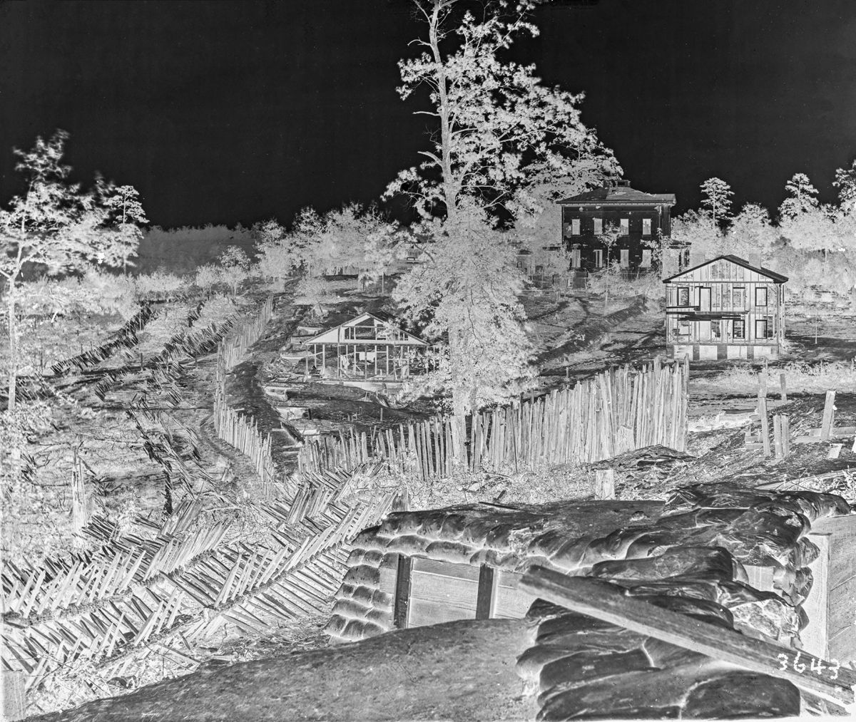
View of Confederate fortifications looking east from Fort Hood in the northwest salient of the GrantPresstman perimeter. The white two-story stucco home of Ephraim G. Ponder is seen on the horizon. Note in the exterior wall shell damage from Union artillery which fired on the house after Confederate sharpshooters occupied the 2nd story. George N. Barnard took this photograph after the fall of Atlanta during the Union occupation. (Library of Congress) Historical Bulletin, vol. 2, no. 8 (September 1934), 19-20.
- Charles F. Bryan, Jr., and Nelson D. Lankford, eds., Eye of the Storm: Written and Illustrated by Private Robert Knox Sneden (New York,
2000), passim.; Charles F. Bryan, Jr., James C. Kelly, and Nelson D. Lankford, eds., Images from the Storm: Private Robert Knox Sneden (New York, 2001), xix-xxi (Sneden chronology); Dana B. Shoaf, “A Good Plan Gone Wrong: Mapping out Chancellorsville—a Union debacle and Robert E. Lee’s greatest victory,” Military History Quarterly, vol. 25, no. 3 (Spring 2013), 45-49. 11. Sneden’s map of Atlanta is found on page 409 of his scrapbook at the Virginia Historical Society (VHS Call Number Mss5:7 Sn237). I thank John McClure, Reference Department Manager, of the Historical Society Library for his help in its location. 12. .America’s Civil War, vol. 23, no. 4 (September 2010) 31; Robert E. Zaworski, M.D., The General and the House on a Hill: General John B.
Hood and the Battle of Atlanta (Alpharetta, Ga., 2011), 20. 13. Keith F. Davis, George N. Barnard: Photographer of Sherman’s Campaign (Kansas City, Mo., 1990), 78. 14. Turner, Navy Gray, 205 (“The Chattahoochee’s 32-pounders and nine-inch Dahlgren had been sent to McCorkle for Atlanta’s defense on May 28”). 15. “Abstract from inspection report of the light artillery, Army of Tennessee…for September 20, 1864,” OR, vol. 38, pt. 3, 683-84 (124 guns for three infantry corps and cavalry).